Posts

Middleton in Teesdale 5 Trigs.

 20th April 2021 A fine run today in warm and clear conditions. Solo and unsupported, 25 miles with 3,250 feet of ascent, 4 hours and 50 minutes. Anti clockwise circuit from Middleton in Teesdale of Harter Fell, Romaldkirk Moor, Grey Carr’s, Raven Hills and Hardberry hill. Some nav required ( would be fun in clag) as some sections of the route were new to me, added to the days adventure.

Durham Dewey Round.

Image
Durham Dewey Round completed 30th September 2018. A Dewey is a hill or mountain in England or Wales over 500 metres (1,640 feet) in elevation, but below 2,000 feet (609.6 metres), with a relative height of at least 30 metres (98 feet). The list was compiled by Michael Dewey and published in his book Mountain Tables. There are 4 in County Durham. I devised a circular route from Stanhope Dales Centre visiting Collier Law, Horseshoe Hill , Bolts Law West and finally Dry Rigg, back through Rookhope. Distance 20.5 miles Ascent 2,600 ft. Terrain rough. We could have picked a better day for the weather but took us 4 hours 50 mins . Thanks to Mike Knipe for planting the idea in my head and Garry Dickinson for good company on the round today .

Hangar 18 X-Fell Shoes.

Image

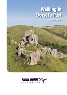
Wolsingham archaeologist is walking in the past.

Image
Sam Ferguson commenced his interest for history and the outdoors while growing up in the Durham Dales. He remembers cataloguing the graves in Wolsingham church, studying the barrows above Rookhope and completing his university thesis studying an enclosure located above Esatgate. Sam left Wolsingham six form college to study Field Archaeology at Bournemouth University graduating with an honours degree. Having lived in Dorset now for eight years Sam has actively explored all area ’ s as a working archaeologist, an outdoor enthusiast and as a tourist. Sam thought what better way to share his passion for the outdoors and history by writing a book. The walks in the book give the reader an insight into the past of Dorset and all it ’ s well preserved archaeological monuments and countryside. Some of the monuments are well known such as Corfe Castle and the Cerne Abbas Giant while others not so familiar. Over the past few years Sam has developed his writing skills by writing articles

3G coverage.

This year I have been to Iceland and Morocco. 3G everywhere, even in places you would not expect to receive. I come back to Weardale in North Pennines and I am lucky to get a signal ? No chance of 3G at all. What has gone so badly wrong in the UK with our Mobile coverage ?

Trail Running in Skopelos.

Image
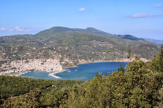
We had been recommended Skopelos in the Greek Islands as a good holiday destination many times, so this September booked it up. After a 3 hour flight to Skiathos, a 5 minute taxi ride to the port a 45 minute wait and then a ferry to Skoplelos Town which took 40 minutes. We based ourselves in Skopelos Town. We rented a car which helped us get to the remote area’s. Mount Delhpi from Mount Palouki.   The trail running in Skopelos turned out to be very good. The island is split by 2 distinct areas. Mount Delphi with the highest peak on the island of 681m and Mt Palouki at 567m. Both of these area’s are accessible running in from Skopelos Town. The most popular route was the Monastery Trail of Palouki from Skopelos Town This is popular with fell walking clubs and proved to be an excellent run.   Running off Mount Palouki on the Monastry Trail. The island also offers Mountain Biking , sea kayaking , diving and sailing activities and well as some remote beaches/

WEARDALE WATERSHED

Image
While many were glued to Cricket at Chester Le Street, Stuart Ferguson ,a Mountain Runner was completing a run of the Weardale Watershed. A round of 24 principle hills above 1,500ft visited in order [ 15 of these are over 2,000ft ], clockwise route from Wolsingham traversing the North and South skyline above Weardale the most northerly of the Durham Dales. The Route devised by Stuart Ferguson, starting at 0500 on Saturday 10 th August 2013, Stuart completed the round solo in 13 hours and 54 minutes, with a Total Mileage: 50.35 and Height Gain: 4,800 feet.   Stu arriving at Killhope Cross after being soaked in a heavy downpour. Picture By Emma Ferguson The route traverses remote, exposed high moorland, peak hags, tussocks with limited rough tracks and trails. Apart from traversing the villages of Wolsingham and Rookope, the only site of tarmac is at high level road crossings. The Weather was Mostly Dry, a couple of heavy rain showers around lunchtime, partly sunny, light